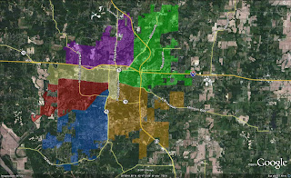
CLICK TO OPEN LARGE VERSION "Go West" First Ward, a new map suggests
COLUMBIA, 8/21/11 (Beat Byte) -- A group of Columbia citizens has created a new Ward reapportionment plan that accomplishes several goals outlined at a July public hearing.The plan expands the First Ward by extending it west through the city's most-populated Second Ward and a small northwest corner of the Fourth Ward.It avoids changes that have motivated charges of "gerrymandering" by leaving the Old Southwest and Benton-Stephens neighborhoods in their current Wards. Finally, it gives the First Ward a growing western boundary, changing its status as the city's only landlocked Ward.Quoting from Columbia school superintendent Chris Belcher, "You get the change you demand," announced Pat Fowler at a meeting she organized last Wednesday night at the Columbia Public Library to get citizen feedback about the Ward reapportionment process, and actual plans from citizens about what they'd like to see.About 25 people attended, drawing the new map and raising concerns about equitable resource distribution, political gerrymandering, and the need to slow the process so that more citizens can be involved. Columbia's Ward Reapportionment Committee must present plans to the Columbia City Council by mid-September, for a process that mostly took place over the summer while many residents were away.
The only Council person in attendance, 6th Ward Councilwoman Barbara Hoppe said she'd check into the tight timeline and see if the deadline could be extended. Her presence also prompted questions about First Ward Councilman Fred Schmidt, whose constituents will be most affected by Ward reapportioning.
Schmidt apparently declined an invitation to the meeting, leaving several First Ward residents scratching their heads.Compare the new Citizens Map to the Ward Reapportionment Committee's current plans -- and two new plans (story to follow) -- by clicking bold-titled links below.
RELATED STORIES
Sidebar
Mobile Menu

 The Columbia Heart Beat
COLUMBIA, MISSOURI'S ALL-DIGITAL, ALTERNATIVE NEWS SOURCE

12
Thu, Feb
